
Tuesday, October 20, 2026
Good morning from Red River, where Tuesday starts cloudy and foggy at 38 degrees, with light west winds and no weather alerts in effect for town. The fog lifts through the morning, skies turn partly cloudy, and the high reaches about 57 degrees before a mostly clear, cold night near 32. West winds pick up to 10 to 11 miles per hour this afternoon, with gusts near 20, so high-profile vehicles should expect some pushing on exposed stretches. In morning checks of state traveler sources, no closures were reported on NM-38 over Bobcat Pass, the rest of the Enchanted Circle, or US-64 through the canyon toward Taos.
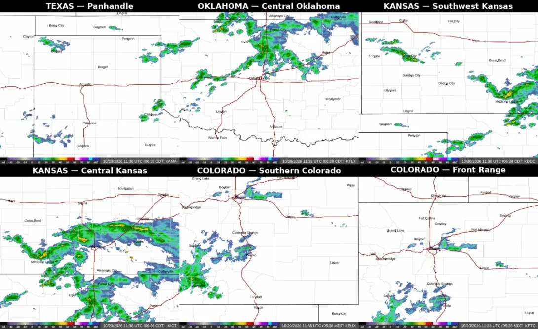
The bigger travel story today is the drive in. This morning's shared Enchanted Circle radar showed rain and storms across almost every corridor that brings visitors to Red River, even though northern New Mexico itself stayed quiet on radar. Showers were showing near Dalhart on US-87 in the Texas Panhandle, heavy rain was falling across central Oklahoma, storms were southeast of Dodge City and across southern Kansas, heavy rain covered central Kansas through Wichita, rain was over Pueblo on Interstate 25 with heavy rain near Alamosa in southern Colorado, and rain was also around Denver on the Front Range corridor. Wet pavement, spray, and slower traffic are the risks on those routes today, not snow or ice.
From Texas and Oklahoma, plan for a damp start and a breezy finish. The Panhandle forecast around Amarillo calls for patchy rain possible today, with south winds gusting into the low 20s, while the radar showers near Dalhart sit right on the US-87 route many drivers use toward Clayton and Raton. Wichita started Tuesday with morning showers and a high near 73, matching the heavy rain the radar showed across central Kansas, and drivers crossing Kansas and Oklahoma should leave extra following distance, watch for ponding in heavy downpours, and be ready to slow down or pull off safely if a storm cell cuts visibility.
From Colorado, Interstate 25 is the wettest route in. Rain over Pueblo and around Denver means a soggy Front Range drive before you ever reach Raton Pass and Springer, and heavy rain near Alamosa matters for anyone coming south on the US-285 corridor through southern Colorado. Check COtrip before leaving Colorado and NMRoads once you cross into New Mexico, and recheck both at fuel stops, because rain that is only an inconvenience in the morning can become standing water and delays by afternoon. No closures on I-25 were reported in morning checks, but that can change quickly on a storm day.
Here at home, the pattern changes tomorrow: Wednesday brings a high near 62 to Red River with afternoon showers likely and rain continuing into the night, so anyone driving the Circle midweek should expect wet pavement over Bobcat Pass and in the canyon. The simple plan for today is to leave early, drive the wet corridors in daylight, keep speeds down on standing water, and save the scenic stops for the dry, sunny stretches around Taos and Red River. With balloon events in Taos and Los Luceros this weekend, October 24 and 25, expect more company on these same roads in a few days.